New Archaeological Sites in Iraq Discovered by AI Using Old US Spy Satellites
A team of scholars at the University of Bologna has developed an artificial intelligence system that can automatically recognise archaeological sites. Using satellite images from the CORONA espionage programme of the 1960s, it has revealed four ancient human settlements that had previously gone unnoticed by archaeologists

A model of artificial intelligence, developed through collaboration between computer scientists and archaeologists at the University of Bologna, has pinpointed four archaeological sites of interest in Iraq, in the Abu Ghraib area, that had previously gone unnoticed by researchers. The discovery – published in the prestigious journal PLOS ONE – came form the analysis of satellite images from the CORONA programme, taken in the 1960s by US spy satellites.
“The deep learning model we developed has shown not only a very high level of accuracy, around 90%, in locating archaeological sites from satellite imagery, but also the ability to discover new archaeological points of interest previously unknown,” explains Marco Roccetti, Professor in the Department of Computer Science and Engineering, one of the study’s authors. “It is an outstanding result, with important implications for safeguarding archaeological heritage, even in landscapes that have been altered by human activity.”
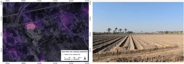
The first step in identifying and locating the remains of ancient human settlements is the observation of the landscape. Archaeologists have several tools available for this purpose, and one of the most widely used is the analysis of aerial photographs. From these images, an expert eye can pick out specific land formations that may reveal the presence of an archaeological site hidden beneath the surface.
For several years, archaeologists and computer scientists at the University of Bologna have been working on an artificial intelligence system to speed up and improve this analysis, using the alluvial plain of southern Mesopotamia as a case study. After achieving a series of results with recent high-resolution satellite images, the system has now been testedon a historical series of less resolved , panchromatic (i.e. grayscale) images and on a specific area of central Iraq where the University of Bologna held a fieldwork permit.
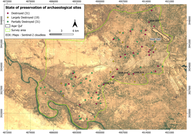
“To test this new tool, we focused on the Abu Ghraib district in the Baghdad region: an area that had never been the subject of systematic archaeological investigations and that in recent decades has undergone profound transformations due to human intervention,” explains Nicolò Marchetti, Professor of Near Eastern Archaeology in the Department of History and Cultures, another author of the study. “For this reason, we trained the system not only with the most recent satellite images, but also with those of the same region taken in the 1960s by US spy satellites.”
The historical images come from the secret CORONA programme, through which the United States mapped the territories of China, the Soviet Union, and the Middle East in the 1960s. Adding these photographs to the datasets fed into the artificial intelligence system made it possible to reconstruct a landscape that has changed drastically over recent decades and thereby reveal archaeological sites never before identified, as they had been almost completely destroyed.
“The role of the CORONA programme images proved to be crucial: not only to improve the system’s analytical capability, but also to relocate archaeological sites that are no longer visible today due to anthropisation of the landscape – through infrastructure, urbanisation, and agricultural work; about half of the sites that still existed half a century ago are today almost completely destroyed,” confirms Marchetti. “Thanks to artificial intelligence, we were therefore able to identify four new settlements that, using traditional archaeological tools and techniques, would have been almost impossible to find given their current state of preservation.”
This innovation – the scholars emphasise – does not replace the work of archaeologists, which remains central, but makes it possible to speed up and simplify the process of analysing satellite images, followed by field verification. Artificial intelligence identifies a series of potential sites of interest, but it is up to archaeologists to assess and validate the results, selecting which ones are the most promising for field checks.
“It is not the first time, in the scientific field, that artificial intelligence tools have suggested new perspectives to human experts on natural phenomena, bringing out unexpected meanings,” concludes Roccetti. “It is an extraordinary result that facilitates and enriches the work of archaeologists and opens up new avenues of investigation, also in connection with other land survey technologies.”
The study was published in PLOS ONE under the title " “AI-ming backwards: Vanishing archaeological landscapes in Mesopotamia and automatic detection of sites on CORONA imagery”. The authors, two professors and two young researchers from the University of Bologna, are Alessandro Pistoia and Marco Roccetti (Department of Computer Science and Engineering), together with Valentina Orrù and Nicolò Marchetti (Department of History and Cultures).